Report on First Field Season: |
| ||
|
|
|
|
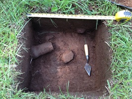
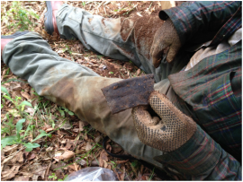
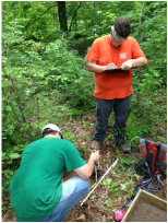
Stone tool cache from Landrum 2 site Ceramic rimsherd from Peacock 1 site Shovel testing at Peacock 1 site
|
|
Research Synopsis
(Disclaimer: this page will remain a work-in-progress that will evolve along with my research. I strongly recommend it not be treated as a citeable reference.)
Understanding the spread of "Mississippian culture" has long been a major preoccupation of archaeologists working in the American Southeast. This focus began in earnest with the founding of the Lower Mississippi Survey (LMS) in 1939 by Philip Phillips, James A. Ford and James B. Griffin. The work of the LMS was critical to the development of the methodological and theoretical underpinnings of modern Southeastern Archaeology and the migration/diffusionist models presented in the publications of the LMS continue to influence modern notions of the evolution of Mississippian culture. Central to the LMS settlement model is the notion of a "Cahokian intrusion" as the prime mover of Mississippian traits to the lower Mississippi River Valley, and beyond.
Like many of the migration/diffusion models that characterized 20th-century anthropological thought, the LMS model has largely fallen out of favor as research has revealed a more variable cultural environment that is poorly accounted for by simplistic migration/diffusion models. For example, it is now understood that in some regions the use of live mussel shell-tempering in pottery, a "classic" Mississippian culture trait, may be the result of an analogous, rather than homologous, process whereby shell temper represents a novel, rather than inherited, trait. This realization should lead researchers to treat the question of analogy vs. homology as an opportunity for hypothesis testing to understand how these processes affected cultural change through space and time.
With the above thoughts in mind, my research will focus on modeling the transmission of cultural traits through the Big Black River Basin during the period of pottery production in the region. This period is thought to have begun with the appearance of pottery at the end of the Late Archaic period around 2000 B.C. and continued into the period of settlement by Europeans. A number of methods will be brought to bear on the delineation of site occupations and the temporal and spatial distributions of certain cultural traits. The spatio-temporal mapping of trait distributions will rely heavily upon the analysis of traits associated with ceramic pottery; however, recovered projectile points may also be used. By establishing a baseline of cultural change for this period and region, I hope to identify the processes involved in the appearance and spread of "Mississippian" traits through the region. As the only tributary of the Mississippi River that connects the Mississippi Valley to the eastern portion of the state, the Big Black River represents an interesting and potentially important avenue for the transmission of culture between the Mississippi Valley and eastern Mississippi and western Alabama. Understanding cultural transmission in this region should further clarify the evolution of more eastern "Mississippian centers" such as Lyon's Bluff in northeast Mississippi or Moundville in west-central Alabama.
Natural Setting
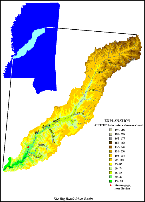
The Big Black River is a tributary of the Mississippi River. Its headwaters are in Webster County near the town of Eupora in the north-central part of the state in the physiographic region known as the North Central Hills. From there it flows in a generally southwest direction until it merges with the Mississippi River 25 miles (40 km) south of the city of Vicksburg. The northern portion of the basin (approximately 40% of its total area) is located within the North Central Hills. The southern 60% of the basin is located in the region known as the Loess Hills. Like the North Central Hills, this region is characterized by gently rolling hills and irregular plains with some areas of acute elevation change. The distinguishing characteristic of the Loess Hills, however, is the thick deposit of loess (in excess of 60 feet) that cap many of the hills or bluffs. Loess deposits are deepest along the western edge of the region and become more shallow as one moves east. The Big Black River Basin (BBRB) is approximately 160 miles (260 km) long and is an average of 23 miles (37 km) wide. Most of its small tributaries are in the upper part of the basin and flow only part of the year. Approximately 56% of the land is forested and 39% is used for farming and cattle ranching. Because this is a large and diverse region, the flow regime and water chemistry in streams is variable. It is expected that the preservation of the archaeological record in this region should be reasonably good as the basin is sparsely populated without large scale development.
The Big Black River is a tributary of the Mississippi River. Its headwaters are in Webster County near the town of Eupora in the north-central part of the state in the physiographic region known as the North Central Hills. From there it flows in a generally southwest direction until it merges with the Mississippi River 25 miles (40 km) south of the city of Vicksburg. The northern portion of the basin (approximately 40% of its total area) is located within the North Central Hills. The southern 60% of the basin is located in the region known as the Loess Hills. Like the North Central Hills, this region is characterized by gently rolling hills and irregular plains with some areas of acute elevation change. The distinguishing characteristic of the Loess Hills, however, is the thick deposit of loess (in excess of 60 feet) that cap many of the hills or bluffs. Loess deposits are deepest along the western edge of the region and become more shallow as one moves east. The Big Black River Basin (BBRB) is approximately 160 miles (260 km) long and is an average of 23 miles (37 km) wide. Most of its small tributaries are in the upper part of the basin and flow only part of the year. Approximately 56% of the land is forested and 39% is used for farming and cattle ranching. Because this is a large and diverse region, the flow regime and water chemistry in streams is variable. It is expected that the preservation of the archaeological record in this region should be reasonably good as the basin is sparsely populated without large scale development.
Figure 1. Map showing the Big Black River Basin in Mississippi.
Previous Research
While the BBRB represents one of more under-investigated regions in the state, some substantive research has been undertaken there. When considering the lower, middle and upper portions of the drainage our understanding of the archaeology diminishes as we move up the drain, from west to east. The lower portion of the drain has received the most attention in the form of three thesis projects by graduate students from the University of Alabama (Boudreaux 1998, Johnson 1998, Lewis 2008). Johnson's (1998) research is especially relevant since it represents a regional-scale survey project focused on understanding the nature of late prehistoric settlement in the lower valley. Boudreaux's (1997) research is focused on understanding the chronology of occupation and mound-building at the Cotton Mounds site (22WR614), while Lewis' (2008) is focused on investigating the notion of the lower BBRB representing a "frontier" region between Mississippian and Plaquemine culture areas. Lewis compares pottery from a number of sites in the region in order to address this research question.
Only one major research project has been undertaken in the the middle portion of the drainage (Lorenz 1990, 1992, 1996). Lorenz's work represents his dissertation research efforts at the University of Illinois, Urbana-Champaign. His research area was focused on the site of the Old Hoover Mound (22HO502), however, he undertook investigations at a number of other sites surrounding Old Hoover that were believed to be part of the same late prehistoric settlement pattern.
The upper portion of the BBRB has seen very little archaeological research. This is evidenced by the fact that in Webster County, in which much of the upper portion of the drainage is located, only 44 archaeological sites have been recorded. In contrast, there are presently 660 sites recorded in Oktibbeha County, which lies immediately to the east of Webster. Only one small testing project has been undertaken in this region (Marshall 1990).
Methods
When considering the archaeology of the Midsouth, the LMS provides a rare example of a problem-oriented, regional-scale research project. Ironically, however, despite its regional-scale approach, the lasting legacy of the LMS has been the promotion of investigations at the scale of individual sites, primarily mound sites. Intent on identifying instances of the displacement of indigenous, Coles Creek culture by northern Mississippian culture, subsequent LMS researchers focused their attention on stratigraphic excavations of mound sites. It was thought that temporal trends, as revealed in stratigraphic change, would provide the evidence needed to support the portrayal of an intruding and displacing cultural force emanating from Cahokia.
Understanding a phenomenon such as the transmission of cultural traits through space and time should be most effectively accomplished through the use of investigative methods that are appropriate to the scale of the phenomenon. Investigating cultural transmission requires a spatial breadth and temporal depth that is simply unavailable through the investigation of a single site, regardless of the intensity of investigation. While temporal depth may be available, spatial breadth is, of course, highly restricted. When undertaking regional-scale studies there is often a trade-off whereby the investigation of large numbers of sites allows for only minimal investigation of each site. Efforts will be made to overcome this problem through the development of an appropriate sampling strategy. Methods will be chosen that lead to the recovery of representative samples of artifacts from each site, while doing so in as expeditious a manner as possible.
References Cited
Boudreaux, Edmond A., III
1997 Chronology at the Cotton Mounds, Warren County, Mississippi. Unpublished Masters Thesis, Department of Anthropology, University of Alabama, Tuscaloosa.
Johnson, Hunter B.
1998 An Archaeological Survey of the Lower Big Black River Valley Near Vicksburg, Mississippi. Unpublished Masters Thesis, Department of Anthropology, University of Alabama, Tuscaloosa.
Lewis, Clifford T., III
2008 Excavations at the Chittoloosa Site (22WR631): Exploration of a Late Prehistoric Frontier in the Lower Big Black Region of West-Central Mississippi. Unpublished Dissertation, Department of Anthropology, University of Alabama, Tuscaloosa.
Lorenz, Karl G.
1990 Archaeological Survey and Testing Within a Five Kilometer Radius of the Old Hoover Platform Mound in the Big Black River Valley. Mississippi Archaeology 25(1): 1-42.
1992 Big Men in the Big Black Valley: Small Scale Late Prehistoric Community Organization in Central Mississippi. Unpublished Dissertation, Department of Anthropology, University of Illinois, Urbana-Champaign.
1996 Small-Scale Mississippian Community Organization in the Big Black River Valley of Mississippi. Southeastern Archaeology 15(2):145-171.
Marshall, Richard A.
1990 Report of Determination of Archaeological Significance of Two Sites in the West Extension, Eupora Industrial Park, Webster County, Mississippi.
